At least 8 people are dead after tornado-spawning storms strike the Central US Memorial Day weekend

CNN
—
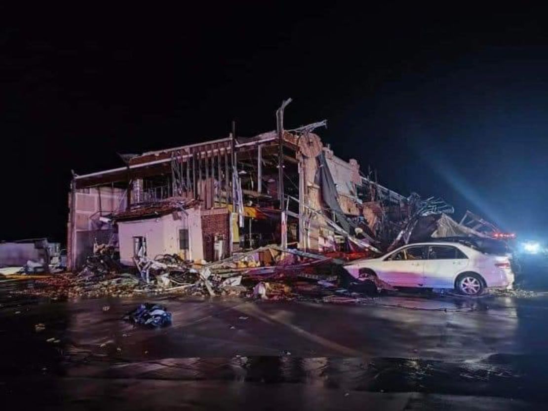
At least eight people, including children, are dead, after suspected tornadoes struck the central United States overnight, as severe storms caused power outages and forced residents to shelter in-place on Memorial Day weekend.
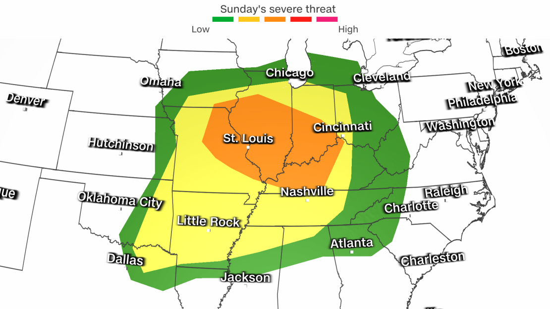
Meanwhile, more than 110 million people across broad swaths of the US are under threat of large hail, damaging winds and a fierce twisters Sunday, mainly throughout the mid-Mississippi, Ohio and Tennessee River valleys. As the storms move east, the Storm Prediction Center warned of “violent tornadoes, extreme hail and corridors of widespread wind damage.”
Five fatalities were reported in Cooke County, Texas, including three in one household, Cooke County Sheriff Ray Sappington told CNN on Sunday morning. Two children in the area were reported missing and are still unaccounted for as of Sunday morning.
Another person was killed in Benton County, Arkansas, the county’s safety administrator told CNN.
In northeast Oklahoma, two people were killed and at least 23 were injured as a result of severe storms overnight, local officials told CNN.
After severe storms tore through Northeast Oklahoma Saturday night, 23 people were injured, electrical substations were downed and the city of Claremore was left with no operating gas systems, Claremore City Manager John Feary said.
Among the injured, 19 were transported to hospitals, three with potentially critical or life-threatening injuries, Feary said.
Inside a Shell gas station in Northeast Texas, 60 to 80 people were trapped until the storm blew over, Sappington said. Multiple injuries were reported at the station, but none were life-threatening, he added.
Many vehicles were damaged and destroyed, leaving about 40 people stranded. They were transported by bus to another gas station in Gainesville, where they were picked up by family members.

In north Denton County, Texas, a possible tornado injured an unknown number of people, damaged several homes, overturned 18-wheelers, downed trees and knocked out power lines on Saturday night, authorities said early Sunday. Deputies responded to multiple locations, including “homes and RV trailer parks,” Dawn Cobb, a county spokesperson, said in a news release.
“Multiple victims” were reported in Ray Roberts after severe weather struck the area overnight, City of Denton fire officials said, adding medics and other resources have been sent to the scene.
Damage to several homes was also reported in the neighboring city of Celina, where officials said the city was affected by “apparent tornadic activity” on Saturday.
The National Weather Service office in Fort Worth issued several tornado warnings for multiple North Texas cities late Saturday night, telling residents to seek shelter immediately as a tornado was seen heading east between Valley View and Sanger around 10:40 p.m.
Lake Ray Roberts Marina in the city of Sanger in Denton County sustained damage to boats, boat houses and the fuel dock by the severe weather Saturday night. Despite reports of people rescued after being trapped in overturned RVs, there are no reports of serious injuries.
“There is so much damage, we don’t even know where to start,” the marina said in a Facebook post Sunday morning.
“We know the boat houses are heavily damaged, all have lost walkways, and most boats are damaged,” the post said. “We lost our fuel dock and offices along with our dock cat, Ginger.”
In Bentonville, Arkansas, crews are working to respond to power outages and emergency medical calls, according to Mayor Stephanie Orman.
“We have crews mobilized throughout the city. We have power lines, down– about 10,000 probably out with power. We’ve got trees across roads, we’re really encouraging individuals to stay off the roads as we tried to clean up those road systems. We also have signals down,” Orman said. “We have had over 20 EMS calls and so those are currently being worked.”
Across state lines, damage was also reported throughout Rogers County, Oklahoma, after a possible tornado swept the area, downing power lines and trees and damaging homes. In the city of Claremore, officials said there was “a lot of damage” and electricity will be out for much of the city “for an extended period of time.”
As the stormy weather battered the region, more than 250,000 homes and businesses throughout the Plains and Missouri were without power early Sunday, including over 93,000 customers In Missouri, around 48,000 in Kansas, more than 34,000 in Texas and 24,000 in Oklahoma, according to poweroutage.us.
Storms that developed overnight in Kansas, Oklahoma and Missouri are now moving east toward the lower Ohio River Valley, triggering a new tornado watch for parts of Arkansas, Illinois, Kentucky, Missouri and Tennessee until 10 a.m. CT, according to the Storm Prediction Center.
Northwest Arkansas, Eastern Kansas, Western Missouri and Northeast Oklahoma are also still under tornado watch until 5 a.m. CT.
There is a Level 3 of 5 risk of severe thunderstorms over parts of the Mississippi and Ohio valleys into Monday morning, and EF2 to EF5 tornadoes and wind gusts of 74 mph are possible, according to the Storm Prediction Center. A Level 4 of 5 risk of severe thunderstorms also exists in parts of the Central and Southern Plains through Sunday morning.
Robust thunderstorms will continue over parts of the Mississippi Valley through Sunday morning before gradually losing their strength. But a new round of damaging storms is expected to arrive quickly after.
Thunderstorms will develop over parts of the Midwest by Sunday afternoon and grow farther south and east through the evening and overnight hours. Powerful storms could ultimately stretch from the Great Lakes to the South Sunday night.
Storms will move toward the East Coast Monday, bringing disruptive high winds and large hail from DC through the southeast.
The travel hubs of Chicago, Indianapolis, St. Louis and Nashville could have to contend with damaging storms, leading to delayed or canceled flights.
The potential for heavy rain over parts of the Ohio and Tennessee Valleys, middle Mississippi Valley, and Central Appalachians prompted the slight risk, Level 2 of 4, of excessive rainfall in those regions through Monday morning.
Cities like Louisville, Kentucky; Cincinnati; St. Louis; Nashville, Tennessee; and Indianapolis are among the cities included in the Level 3 threat. It’s possible the severe weather could affect the Indianapolis 500 race slated for noon ET on Sunday.
The National Weather Service office in Indianapolis forecast showers and thunderstorms, mainly before 4 p.m. ET in Speedway, Indiana, on Sunday, with an 80% chance of precipitation and gusts as high as 25 mph.
The last time rain shortened the Indy 500 race was in 2007 after 166 laps, according to the Indianapolis Motor Speedway.

The unofficial start of summer is also ushering in sweltering heat, reaching potentially record high temperatures for parts of the US on Monday.
Houston; New Orleans; Miami; Mobile, Alabama, Tampa, Florida; and Charleston, South Carolina, are among locations where warm weather will feel more like July than late May through the holiday weekend.
A subtropical upper-level high over Mexico will help spawn excessive heat warnings and heat advisories over southern Texas through Monday, according to the Storm Prediction Center. “The ridging will create a dangerous early-season heat wave over south Texas and southern Florida,” according to the center.
Daily high temperatures and heat index reading exceeding 115 are possible in some areas, the Storm Prediction Center noted.
Those spending time outdoors or who are dealing with a loss of power should drink enough water, dress in lightweight clothing and locate cooling centers if necessary.
CNN meteorologist Elisa Raffa and CNN’s Jillian Sykes, Joe Sutton and Chris Boyette contributed to this report.
Source link


